

6,000.00 - 8,000.00 / Day
Get Best Price
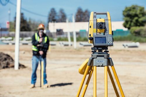
| Usage | Precision Surveying Using Advanced Electronic Instruments |
Total Station Surveyor – Precision Surveying with Advanced Instruments
A Total Station Surveyor is a professional who uses advanced electronic surveying instruments known as Total Stations to measure angles, distances, and elevations with high accuracy. These surveyors play a vital role in land development, construction, infrastructure projects, and property documentation by delivering precise survey data and digital maps.
The Total Station integrates electronic distance measurement (EDM), angle measurement, and data recording, allowing surveyors to collect field data quickly and accurately. A Total Station Surveyor can generate detailed topographic maps, 3D terrain models, and CAD-based layouts, which are crucial for engineering design and project execution.
Key Applications of Total Station Surveys:
Land & Property Surveys: Accurate boundary marking and legal documentation.
Construction Layouts: Aligning foundations, columns, roads, and utilities.
Topographic & Contour Mapping: Recording terrain levels for planning.
Infrastructure Projects: Supporting roads, bridges, railways, pipelines, and drainage systems.
Volume Calculations: Estimating earthwork for excavation and embankments.
Hiring a professional Total Station Surveyor ensures speed, accuracy, and efficiency compared to traditional survey methods. Their data eliminates manual errors, saves time, and provides precise inputs for architects, engineers, and developers. Total Station surveys are also widely accepted for government approvals, legal disputes, and land registration due to their reliability.
Looking for "Total Station Surveyor" ?
Day


