

5,000.00 - 8,000.00 / visit
Get Best Price
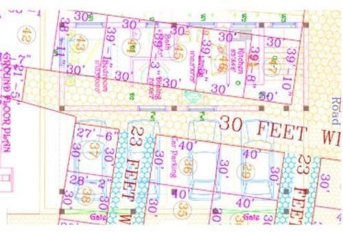
Layout Survey – Accurate On-Site Transfer of Plans
Layout Survey is an essential step in land development and construction projects, involving the accurate transfer of approved building or site plans onto the ground. It ensures that plots, roads, utilities, and structures are positioned exactly as per the architectural and engineering drawings. Layout surveys serve as the foundation for **error-free construction, legal compliance, and efficient land utilization.
Using advanced surveying instruments like Total Station, DGPS, Auto Level, and GPS equipment, professional surveyors mark reference points, grid lines, and dimensions on-site with high accuracy. The process includes boundary verification, alignment checks, and positioning of columns, foundations, and utilities, ensuring that the development matches approved designs.
Key Applications of Layout Surveys:
- Residential & Commercial Layouts: Marking plots, roads, and open spaces.
- Townships & Housing Projects: Ensuring proper division of land as per authority approvals.
- Industrial & Institutional Projects: Positioning structures and utilities with precision.
- Construction Works: Transferring grid lines for columns, foundations, and walls.
- Government Compliance: Meeting standards set by municipal and development authorities.
A layout survey prevents misalignment, boundary disputes, and construction errors saving both time and cost. It also provides developers with accurate site records, which help in property sales, approvals, and long-term project management.
Whether for real estate plotting, township planning, or commercial and industrial development, hiring a professional Layout Surveyor ensures accuracy, transparency, and smooth execution**.
Looking for "Layout Survey" ?
visit


