

6,000.00 - 8,000.00 / Day
Get Best Price
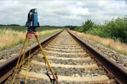
Railway Track Survey – Precision Planning & Mapping for Rail Infrastructure
A Railway Track Survey is a highly specialized survey conducted for the planning, design, construction, and maintenance of railway lines. It involves precise measurement and mapping of terrain to determine the most feasible and cost-effective alignment for tracks. Railway surveys ensure **safety, durability, and efficiency while complying with *engineering standards and government regulations.
Using advanced instruments such as Total Station, DGPS, Auto Level, Drone Mapping, and GIS technology, railway surveyors record data on ground levels, curves, gradients, and obstacles. This data is used to create topographic maps, alignment drawings, longitudinal and cross-sectional profiles, forming the foundation of railway engineering.
Key Applications of Railway Track Survey:
Route Selection & Alignment: Identifying the shortest, safest, and most economical path.
Earthwork Estimation: Calculating cut-and-fill quantities for track beds and embankments.
Bridge & Tunnel Planning: Surveying terrain for supporting structures.
Track Upgradation: Assessing existing lines for gauge conversion or capacity enhancement.
Drainage & Safety Checks: Designing proper slopes to prevent waterlogging and accidents.
Railway track surveys are essential for new railway lines, metro projects, high-speed corridors, freight corridors, and station expansions. They provide accurate data that helps engineers reduce construction costs, ensure smooth train movement, and minimize long-term maintenance.
Looking for "Railway Track Survey" ?
Day


