

Cross Sectional Survey – Accurate Terrain Profiling for Infrastructure Projects
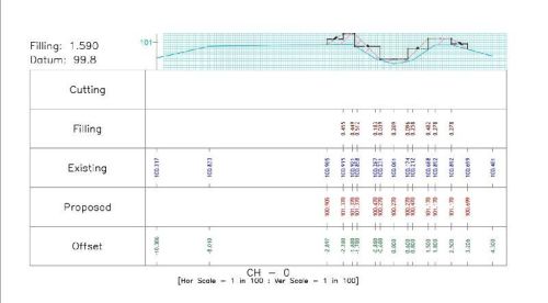
A Cross Sectional Survey is a specialized type of land and engineering survey used to measure and represent the shape, elevation, and profile of the ground at regular intervals along a specific alignment. This survey is essential for infrastructure projects such as roads, railways, canals, pipelines, bridges, and drainage systems, as it provides accurate data on terrain variations and ground levels.
Using advanced instruments such as Total Station, GPS/DGPS, Auto Level, and Drone Technology, surveyors collect detailed information at fixed intervals along the alignment. This data is then used to create cross-sectional drawings** that represent the vertical profile of the land in relation to the project design.
Key Applications of Cross Sectional Surveys:
- Road & Highway Construction: Determining cut and fill quantities for earthwork.
- Canal & Drainage Projects: Calculating water flow capacity and ensuring proper gradient.
- Pipeline Installation: Mapping terrain variations for accurate alignment.
- Railway Projects: Designing stable and safe track beds.
- Structural Foundations: Assessing ground conditions for bridges, culverts, and embankments.


